The luxurious villa “Afeidia” is located in the area of Kafkala-Mahairida, 2, 5 km away from the village Chorafakia, in the northwest part of the Municipality of Akrotiri. It was named after the abundance of biodiversity and the natural beauty that surround it.


The picturesque city of Chania is the second largest city of Crete, after Heraklion, with more than 60,000 residents. Fortunately, it did not follow the same fate as the other cities of Crete, e.g. Heraklion, where the great Venetian and Ottoman monuments were destroyed for the sake of economic growth and "modernization". Instead, the Old Town and the Venetian Harbour have remained almost intact, giving the city a special Venetian character, unique in the Mediterranean.
Thus, the visitors of Chania are attracted by the beauty of the scenic narrow streets, the imposing lighthouse at the entrance of the small harbor, and all the amazing monuments that make up the transcendent magic of Chania.
https://www.cretanbeaches.com/en/cities-and-towns-in-crete/chania

Elafonisi is located 76km west of Chania and 5km south of Chrysoskalitisa Monastery, in the southwestern-most tip of Crete. Elafonisi is an oblong peninsula, which often breaks into two parts by water giving the impression of being a separate island. It is a Natura 2000 protected area. The island is full of dunes with sea daffodils and jupiners.
The endangered loggerhead sea turtle and several rare animals and plants find shelter on the island; it is strictly forbidden to remove any plants, animals, shells, and sand from the area. Exotic beaches with white sand and turquoise water, reminding of the Caribbean, are formed on either side of the peninsula. The sand is pinkish in many places, taking its color from millions of crushed shells.
Near the breaking point of the peninsula, the seawater does not exceed 1m in depth, creating a small lagoon, ideal for children. You can easily cross the lagoon to reach the opposite side of the peninsula while carrying your staff with you because the water is very shallow there. The eastern side of the beach, in front of the lagoon, is well organized and has the most people. There are umbrellas, showers, lifeguards, snack bars, and changing rooms. Also, near the beach, there is a huge area for parking and, even further, a few rooms to let.
Opposedly, the beaches on either side of the island is less crowded and are the most beautiful, with amazing azure colors. If you want to stay completely secluded or nude, you can walk along the peninsula until you find a quiet cove that you like! There are some coves available for naturists near the west end of the peninsula.
You can come by car (1.5 hours) or by bus from Chania. The road to Elafonisi is narrow and full of turns, but the beauty of the landscape is stunning; you will cross the beautiful lush green village Elos and the imposing gorge of Topolia. Moreover, there are many options for accommodation at Chrisoskalitissa village, 5km to the north. You can eat at Chrissoskalitissa or at Elos (on the way back to Chania).
https://www.cretanbeaches.com/en/sea-tourism/west-crete-beaches/elafonissi-beach

The exotic beach of Falassarna is located 59km west of Chania city and almost 17km west of Kissamos, at the western base of peninsula Gramvousa. At the northern end of the beach, there are the ruins of the ancient Greco-Roman city of Phalassarna.
Falassarna bay hosts some of the most famous beaches in Greece, which has been awarded as the best beach in Crete and voted as one of the 10 best beaches in Europe several times in the past.
Falasarna spans a large area and consists actually of five consecutive beaches, with the two most central being the favorite. The sand in Falassarna is whitish, making the watercolor tropical. Indeed, if you're lucky and be here on a day that is not blowing from the west (rare in west Crete) you will be enchanted by the beach and its turquoise waters.
The main beach of Falassarna is called Pachia Ammos (i..e Coarse Sand). It is an exotic beach with a length of 1km and a width of 150m. This beach attracts the most visitors to the area, but because of its length, it never seems too crowded. The beach offers umbrellas and a few snack bars and cafes, where you can get food and water.
There are also services for water sports and beach volley courts. There is another long beach north of the main beach having a length of 800m, identical to the main beach, which is separated into several smaller beaches. This bay is divided in half by a dune and a few rocks. The beach is quieter than Pachia Ammos and offers no facilities. Nearby, there is the chapel of Agia Paraskevi and a spring with fresh water. Further north, near the archaeological site, there is a small cove facing to the south. It is pebbly and the seabed is rocky. It is a good choice when the winds blow from the west or you seek isolation.
South of Pachia Ammos, at Livadi, there is another long beach that has a sandy shore and rocky seabed. It is a very good choice for fans of snorkeling. Livadi is surrounded by a very important wetland with ponds, which host many birds in winter. Even southern, near the small harbor of Limeniskos settlement there is a small pebbly beach, which is a good choice if you do not want to stay remote. The area around Falassarna is magnificent and is a protected nature reserve.
If you have time and are looking for something romantic, you can wait for the sunset, which is considered the best in Crete. How could this not be the best, when being in such an amazing landscape and there is no obstacle between the beach and the horizon? When it gets dark, you might be lucky to visit one of the several beach parties organized in Falassarna during the summer.
One drawback about Falasarna is that it looks west and is usually wavy. However, this is desired by windsurfers. There are also reports that the surrounding greenhouses pollute the sea with fertilizers and trash, which, if being true, is a real shame. If you do not have the means to get to Falassarna, you can catch the bus from Chania or Kissamos.
https://www.cretanbeaches.com/en/sea-tourism/west-crete-beaches/falassarna-beach

The famous lagoon of Balos is located approximately 56km northwest of Chania and 17km northwest of Kissamos, formed between the Cape Gramvousa and the small Cape Tigani and below the range of Platiskinos. Balos is surely the most photographed beach in Crete, a very favorite subject of all tourist guides for Greece.
It is no coincidence that Prince Charles and Princess Diana visited Balos on their private yacht many years ago. Balos is famous for its turquoise waters, wild natural beauty, and beautiful exotic scenery.
During the summer, it is visited by thousands of people, who arrive mostly by the ferries running from Kissamos port. If you do not like crowds, you’d better avoid visiting the beach in July and August. Also, a perfect idea is to arrive at Balos in the morning, before the boats arrive from Kissamos.
These few hours of remoteness in such a heavenly place will remain etched in your memory forever. The lagoon of Balos has white sand and exotic white, vivid blue, and turquoise waters. The sea is very shallow and warm, ideal for young children. In many places, the sand has a lovely pinkish color, because of millions of crushed shells. Beyond the rocks at the boundaries of the lagoon, the water is deeper and colder, ideal for snorkeling.
The lagoon and the wider area, with rare species of flora and fauna, are protected under the Natura 2000 program. Eleonora’s falcons, shags, and cormorants nest in the caves of the area. Moreover, the area is a shelter for the protected monk seal and the loggerhead sea turtle (Caretta caretta). Despite the protection, some canteens and umbrellas have appeared on the beach in recent years. You can buy water from there and from the bars of the ferries.
https://www.cretanbeaches.com/en/sea-tourism/west-crete-beaches/balos-lagoon-beach
The Samaria Gorge is the most famous trekking gorge in Europe and a part of the European E4 hiking trail. Thousands of tourists flock here daily in the summer season to walk from the top to the bottom. For many visitors, it is the sole purpose of their visit to Crete. The length of the gorge reaches 14.5km and takes almost 5-7 hours to hike from Xyloskalo at Omalos plateau to Agia Roumeli beach, depending on the trekking pace.
The gorge is located south of Chania Prefecture in the larger uninhabited area of Europe, where no roads even exist. It was created by the river flowing between the main massif of the White Mountains (Lefka Ori) and the range of Volakias. There are many smaller gorges vertical to Samaria Gorge, some of which have never been crossed by humans and require canyoning equipment. One of these, Perdika, has the highest waterfall in Crete (220m).
Spring There are many fresh-water springs along the route.
Water is potable While the gorge is officially 15km long, this distance refers to the hiking distance between the settlement of Omalos on the northern side of the plateau Omalos and the village of Agia Roumeli. The gorge is 13 km long, starting at an altitude of 1,250m at the northern entrance, and ending at the shores of the South Cretan Sea in Agia Roumeli.
The walkthrough of Samaria Natural Park is 13 km long, i.e., from the ticket kiosk at Xyloskalo to the kiosk at Agia Roumeli old village, but you have to walk 1.5 more kilometers to reach the beach of Agia Roumeli, making the hike 14.5km.
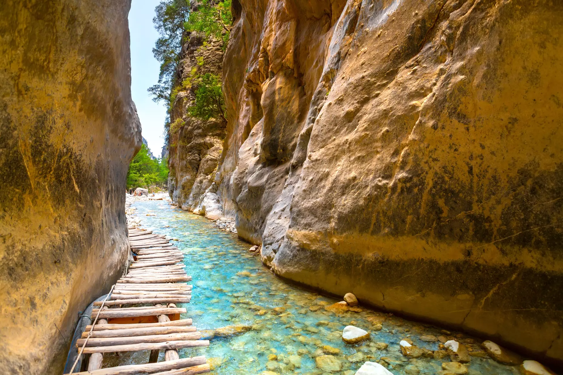
The most famous part of the gorge is the stretch known as the Iron Gates (Sideroportes), where the sides of the gorge close into a width of only four meters and soar up to a height of 500 m. The gorge became a national park in 1962, particularly as a refuge for the rare Cretan ibex, which is today restricted to the Lefka Ori National Park, the island Thodorou and several more islets. There are several endemic species of fauna and flora in the gorge and surrounding area. The desert village of Samaria lies just inside the gorge.
It was finally abandoned by the last remaining inhabitants in 1962 to make way for the park. The village and the gorge are believed to take their names from the village's old church of Mary of Egypt (Osia Maria).
A "must" for visitors to Crete is to complete the walk down the gorge from the Omalos plateau to Agia Roumeli on the South Cretan Sea. From there most visitors get the ferry to the port of Chora Sfakion and catch a coach back to Chania. The walk takes 4-7 hours and can be strenuous, especially at the peak of summer.
The problem with Samaria is crowds. It has become one of the most popular attractions in Crete and there are up to 3000 visitors a day on very busy days. If you have the bad luck to pick one of those days, the atmosphere will be spoilt. Starting at dawn (before the tourist coaches arrive) will give you a bit of a head start.
It is possible to find good and cheap accommodation in Omalos or get the first bus from Chania. You can also start walking after 12:00, there won't be many people and you will have shade at all times, but you will most probably need to spend the night in Agia Roumeli because the last ferry will have left. However, we encourage you to do that, since staying in Agia Roumeli is quite cheap and the beach is majestic. The first tourist buses arrive at around 7:30 am and from then on it is an uninterrupted stream of buses until about 11:00 am.
As far as the times of the year are concerned, the best time is spring: the weather is still cool and the vegetation is at its best. The worst time is in the middle of the summer during a heatwave. Give it a miss and come again at a better time. All local tour operators in Crete provide organized tours to the gorge.
These include bus transportation from your hotel to the entrance (near Omalos village), and the bus will be waiting for you to disembark the ferry in Chora Sfakion to take you back. If you are on your own, you can make a one-day round trip from Chania or Sougia, or Paleochora. Note that the morning buses from Sougia and Paleochora do not operate on Sunday, but still make sure that you know the timetables. The ferries leave Agia Roumeli to Chora Sfakion (east-bound) and Sougia/Paleochora (West-bound) in the afternoon.
There also exists a "lazy way" - from Agia Roumeli to the Iron Gates (more or less an hour of non-challenging terrain) and back.
Descent in the canyon starts from the position of Xyloskalo at Omalos Plateau, at an altitude of 1200m, where you have to pay a small entrance fee for the protection of the reserve. The trail is wooded with cypress and pine trees, wide and very well discernible, while at the beginning descends abruptly. We meet drinking water and toilets very often. In about three hours we reach the old village of Samaria, at an altitude of about 300 meters, after crossing by the church of Saint George.
In Samaria there are old houses, trees offering shade, water springs and if you are lucky you will meet the endangered Cretan wild goat. From here onwards the landscape changes, becomes drier and the slope gets smooth. One hour later we walk along the riverbed for some time. There are several small wooden bridges in several places, above the river.
After one more hour, we meet the imposing Sideroportes (Iron Gates) which is a very narrow passage between two tall vertical 500m high cliffs. We soon reach the old village of Agia Roumeli which was abandoned in the mid-1900s due to a devastating flood and was moved to the seaside settlement of Agia Roumeli, which is about 30 minutes away.
Operates May 1 - October 31, opens daily at 7:00
(Sometimes, due to bad weather the gorge remains closed, so it’s a good idea to call +30 2821067179 before coming)
https://www.cretanbeaches.com/index.php/en/gorges-and-canyons-in-crete/west-crete-gorges-chania/samaria-gorge
